Site context
The site is located on the edge of Trull, comprised of two fields west of Honiton Road and to the south of the Queen’s College. When travelling past the site on Honiton Road, views directly into the fields are currently obscured by a large mature hedgerow, as well as several properties to the south east of the site boundary.
The site is close to local amenities, including a GP practice, a Tesco supermarket and a local shop, several outdoor recreational spaces, and places of worship. The site is also in walking distance from Bishops Henderson and Trull Primary schools.
Existing mature trees and hedgerows follow the perimeter of the site, except for the southern boundary where a new green edge is proposed to make use of the existing tree and follow the historic hedge line. These are a feature of the site and contain the site visually.
Local planning policy context
In planning policy terms, along with the whole of Trull, the site is within the settlement boundary for Taunton and within the Principal Urban Area, as identified in the adopted Taunton Deane Core Strategy, where developed should be focussed. The northern field is within a Conservation Area.
Uniquely for land that is within the settlement boundary of Taunton, the site is also designated as part of a Green Wedge although Somerset Council has recently commissioned independent consultants to undertake a Green Wedge Review which has concluded that the site does not meet any of the stated Green Wedge policy objectives.
The Taunton Deane Core Strategy was adopted 14 years ago and is no longer consistent with more recent national planning policies.
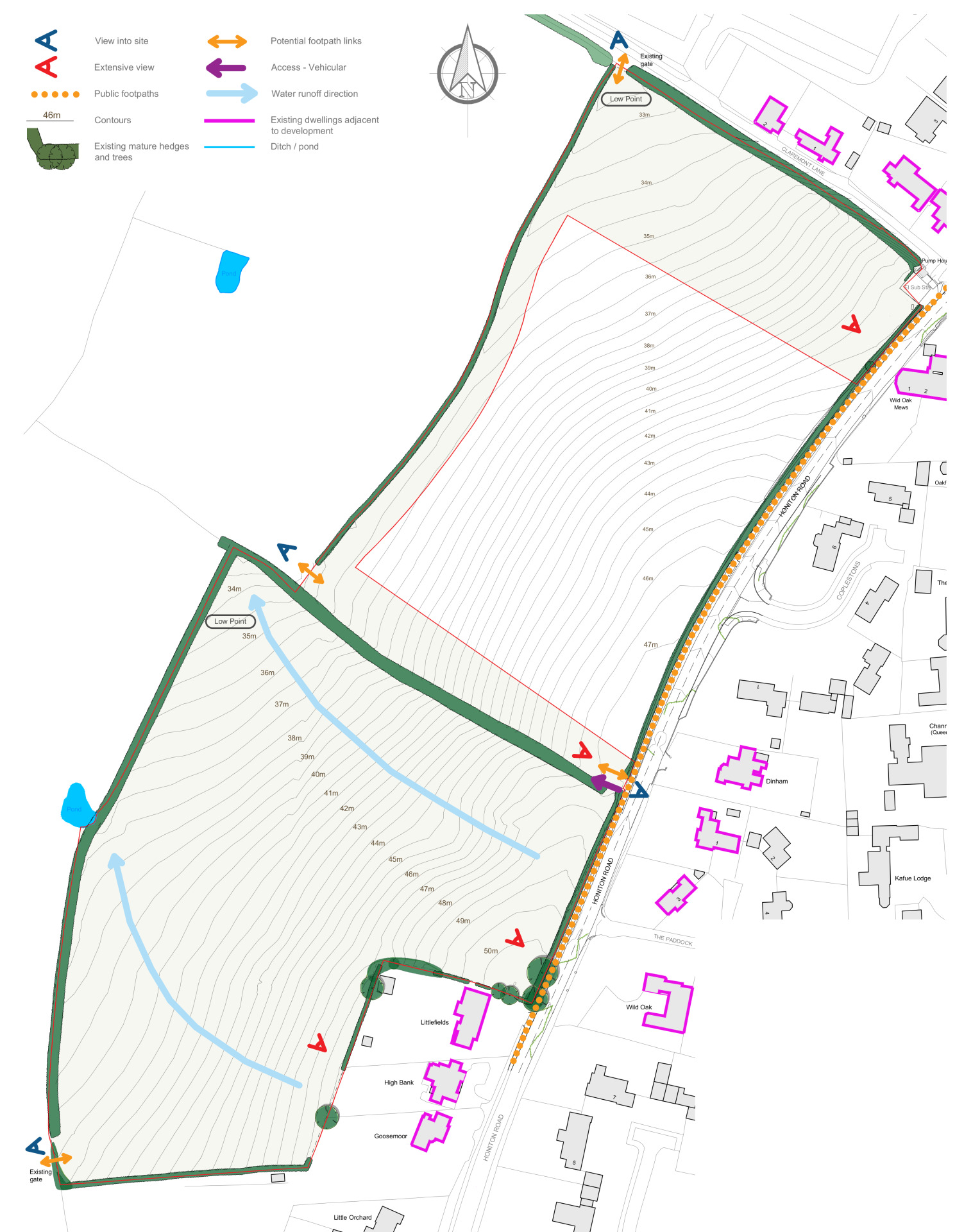
Constraints and opportunities which have influenced the proposed plan for the site - click to enlarge
Design principles
Our focus is on Garden Town principles and place-making, with a clear and legible street hierarchy that uses green infrastructure to its advantage, providing a safe movement network that connects spaces and places.
The tree lined access road follows similar principles to the existing tree lined roads found further along Honiton Road in Queen’s Drive. It will integrate the development to the site and break up the roofscape visible from the south and west of the site.
Streets are designed to naturally calm traffic and prioritise pedestrians, incorporating carefully integrated on-street parking, electric vehicle charging points, pathways, and frontages. New homes set along private drives will have sufficient private frontages and face green open spaces with informal tree and native shrub planting with landscape buffer beyond.
Our aim is also to:
- Provide high quality new homes in a range of types, sizes and tenures, including affordable homes, designed in keeping with neighbouring homes and public buildings (limited to 2 storeys throughout).
- Promote walking or cycling to local amenities and create a legible network of streets and places throughout the site.
- Retain the established green infrastructure and wildlife habitats, ensuring that it remains as an important feature and backdrop for the site.
- Enhance the local cycle network with a new north-south, 3m-wide cycle connection running through the site.
- Create a new public open space, accessible for all, for the enjoyment of the residents and visitors to the site.
- Provide active frontages and natural surveillance over the public realm and pedestrian routes.
- Deliver a mix of market and affordable housing.
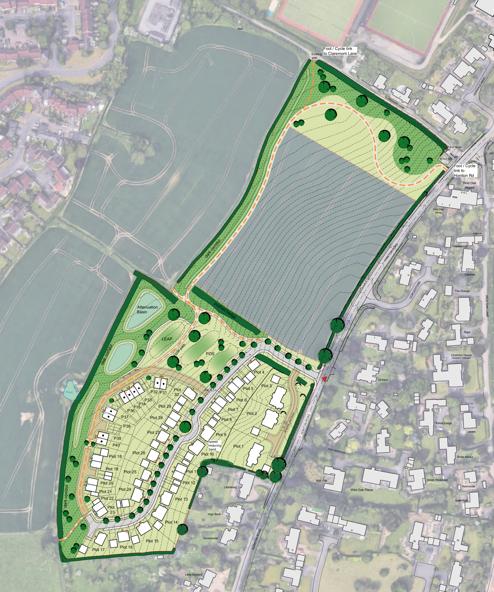
Proposed site plan - click to enlarge
Sustainable transport
The site is well located for pedestrian and cycle routes, both into Taunton and into the surrounding countryside and village communities to the south.
The proposals include a new 3m-wide cycle and pedestrian connection running through the site, linking Claremont Lane in the north to Honiton Road in the south, enhancing north-south links between Taunton town centre, Trull and villages to the south.
There are a number of facilities within walking distance from the site, as well as two bus stops which provide connections further in Taunton and towards Trull without the need to always rely on a car.
Local housing need
Somerset Council has a substantial shortfall in its five-year housing land supply for the former Taunton Deane area which these proposals can help to address. The Government is seeking to significantly increase the scale of housebuilding both nationally and in the local area, recognising that the scale of housing that has been built has not met actual housing needs for decades and this has caused home ownership to become unaffordable for many people, particularly young people.
Landscape and open space
Existing hedgerows and trees on the boundaries of the site will be retained to maintain existing visual screening and existing views across the site from neighbouring buildings.
Part of the northern field will be retained as informal public open space, play spaces and landscaped areas, which will help achieve biodiversity net gain.
The western edge of the site will include a landscape ‘buffer’, approximately 10 to 15 metres in width, with the existing boundary hedgerow and group of trees retained and reinforced with some new tree and shrub planting and open grassed areas. The proposed new homes are set back from this boundary. This buffer could also accommodate drainage features,and other ecological enhancements to enable biodiversity net gain.
The plan includes the introduction of an area of open space and planting, including tree and shrub planting, along the northern edge of the site.
The proposals will create a strong tree lined street along the road extending through the site, including incidental areas of open space.
Ecology
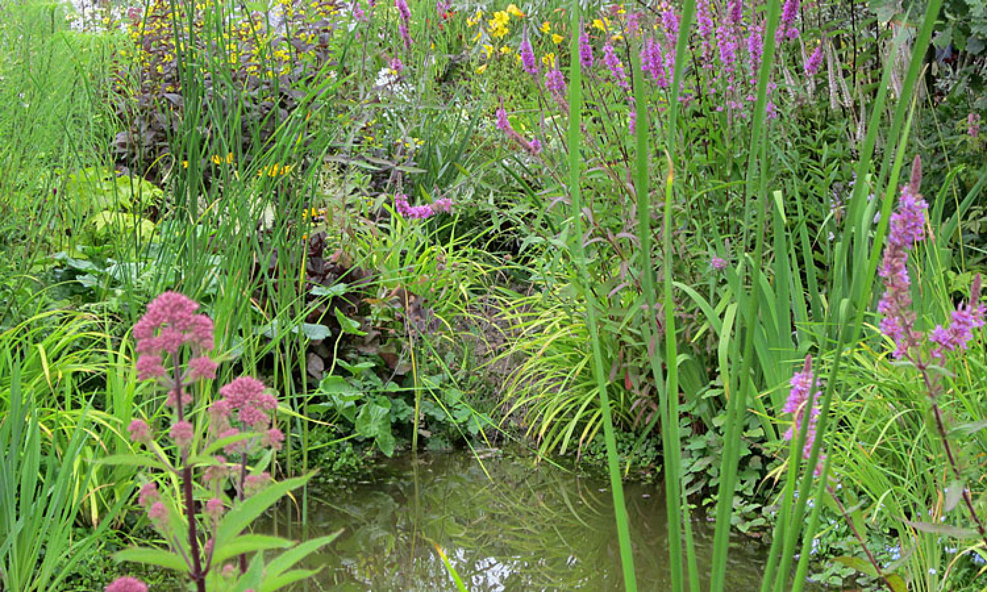
The proposals include the retention and enhancement of existing boundary trees and hedgerows, as well as a 'dark corridor', that will provide valuable commuting and foraging habitats for local wildlife. The proposed flood attenuation pond will also provide ecological benefits.
Drainage
Sustainable drainage is proposed in the way of several water attenuation ponds along the western boundary of the site (outside of any tree root protection zones). Further drainage measures will be utilised as the design of the scheme progresses.
Vehicle access and car parking
Vehicular access will be provided via Honiton Road.
The proposed layout provides appropriate off-street parking in accordance with Somerset Council's parking standards, and is designed so that service and emergency vehicles are not restricted, as well as ensuring that the road network is safe for all users.
Car parking is included on plot to the side of the proposed new homes in most cases and, in some instances, parking is included to the front of the home.
Cycle parking has been provided on plot, either in the garages or in separate garden sheds. All homes will provided with an electric vehicle charging point.

Energy efficiency
The proposed design applies a ‘fabric first’ approach to sustainable construction, reducing energy demand through improvements to the built fabric of the homes, low air leakage and additional passive and active demand reduction measures as a first principle. This ‘fabric first’ approach ensures that energy demand reductions will be built into the lifetime of the new homes.
Recycling and refuse
The site will be designed for council waste collections. Where homes are served by private drives, recycling and refuse collection points have been incorporated into the design to ensure council refuse operators can service all homes safely and efficiently.